Praying Our Most Accurate Long-Range Weather Model is Wrong About Next Week’s Minnesota Forecast
Low Confidence Model Outlook
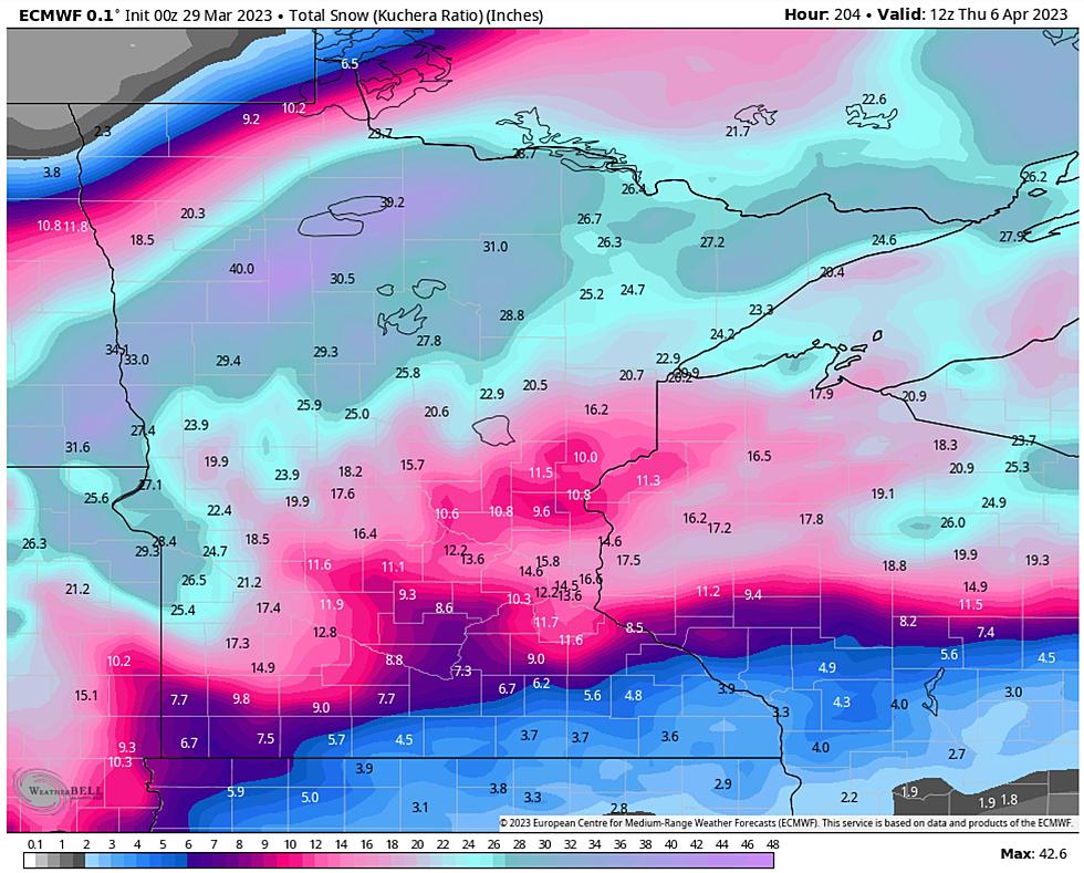
I am just the messenger. Frankly, I'm ready for Mud Season. I look forward to complaining about mosquitoes and humidity and thunderstorms washing out my precious weekend activities. Those days are coming, but no time soon. The map above is from the latest European model, still - by most metrics - the most accurate weather model on the planet. Not perfect, but consistently better than other options. This is a prediction of total snowfall by Thursday morning of next week. Caveats aside, the forecast above is "low confidence". It's still very early.
Most of the (predicted) snow over the northern third of Minnesota and Wisconsin above comes next Tuesday into Wednesday and yes, this may all be a head-fake from Old Man Winter. The storm may still track south or swerve north or evaporate altogether. Posting this may be premature, even reckless. Apologies to my old meteorology professors at Penn State tuning in, but ECMWF has done a pretty good job this winter, and I wanted to tee this up now.
Note to self: there's still plenty of time to stock up on toilet paper, milk and eggs. Deep breaths.

Low Confidence Model Outlook
NOAA's GFS (Global Forecast System) model is even more aggressive, and no, I do NOT think the Northland will pick up 2-3 FEET of snow over the next 7-8 days. But another foot? Quite possibly, yes. Keep in mind the all-time snowfall record at KDLH is a whopping 135.4" set during the winter of 1995-96, according to the Duluth National Weather Service. At the rate we're going we could overtake that number by the middle of next week. Good grief.


As of this morning winter snowfall in the Twin Ports stands at 125.8", so it won't take that much to get up into the Top 5 Winters, and using higher math I've calculated only 9.7" to set a new all-time snowfall record. Something we'll be telling our kids about. Our therapists too...

Higher Confidence Model Outlook
There is higher confidence for the first snow event coming in late Thursday and Thursday night, with the heaviest snow probably setting up over far southern Minnesota and Wisconsin late Friday. But a 2-5"+ snowfall is quite possible Thursday night in the Twin Ports. It will probably be plowable.
There are many unknowns and this forecast WILL CHANGE over time as newer, more accurate data fuels the models. Again, we're talking about two snow events: one later this week and what may be a much bigger snow and ice storm next Tuesday into Wednesday morning. Slush in the stands for the Twins Home Opener at Target Field next Thursday anyone? I'm shocked.
And no, a Northland Spring is not for the faint of heart.
The 16 Least Snowy Winters On Record In Duluth History
Gallery Credit: Nick Cooper - TSM Duluth
More From KOOL 101.7