Pat Benatar Was Right: Fire and Ice in the Forecast, Serious Flooding for Parts of Northland
Welcome to the definition of a "light-switch spring". Flip a switch: it's spring! Which is, of course, welcome, but the sheer velocity of this warm front (it as 69F yesterday at Duluth) has created very rapid melting and serious flooding for parts of the Northland. The Twin Ports had 30" of snow on the ground a couple days ago. Snowfall is now down to 9" and dropping fast. There was 5-8" water trapped in all that snow, a near-record amount. All that additional water is being flushed into streets, streams (and basements)

The local National Weather Service office reminds all of us to be aware of these dangerous conditions, don't drive into flooded roads - it's impossible to estimate how deep the water is, especially at night. Only 6" of moving water can knock you off your feet. Two feet of rapidly moving water can float your car or pickup. Turn around - don't drown. Most flooding deaths occur in vehicles. Take it easy out there.

Meanwhile the Mississippi River is flooding in Aitkin:

Serious flooding is occurring in Douglas and Bayfield counties in Wisconsin:

The Nemadji River is out of it's banks in Douglas county Wisconsin:

Meanwhile, the combination of record heat, gusty winds and low relative humidity (around 20%) is creating ideal fire weather conditions across southern Minnesota, including the Twin Cities. Small blazes may spread quickly under these circumstances:

Now for the ice part of the equation. Models print out a little snow over western Wisconsin late Sunday and Sunday night, but I'm hoping it's all a big nothing-burger with no new snow sticking on the ground across the Northland. Here is the latest European model snowfall prediction:

One thing is exceedingly clear, after a few mild days we are due for a minor "correction" with a run of 40s and 50s next week. Old Man Winter is going down, but it won't happen as fast as many of us would like. Here is the European model prediction:

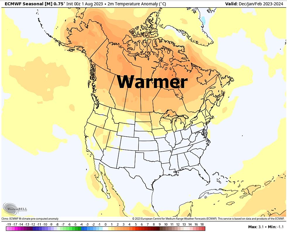
"Cool and sloppy with a risk of flooding" pretty much sums it up. At least we got a taste of spring. A long, hot (sweaty) summer may be on the way, courtesy of a developing El Nino warming pattern of Pacific Ocean Water.
The rest of 2023's weather is an enigma wrapped in a riddle. One day at a time. Keep an eye out for flooding and do your best to stay dry in the coming days.
Better days ahead.
12 Reasons Not To Look Forward To Spring
Gallery Credit: Zane Mathews
More From KOOL 101.7