Is Your Street In Line For Repairs? Here’s What Duluth Streets Are Getting Worked On In 2026
Winter is finally over (I hope), and that means Minnesota's other season is here: Road construction season. While we might loathe the inconveniences that come with the work, the end outcome is worth it, right?
The City of Duluth manages 450 miles of local streets within its jurisdiction, and they say 55% of them are in "poor" condition. That news probably doesn't come as a surprise to a lot of locals used to having to dodge potholes every day.
Back in March, I dug into data from the City of Duluth to see just how bad the city's streets are and which neighborhoods have streets in the worst condition.
Eight different Duluth neighborhoods scattered throughout the city were among the worst, ranging from Gary New Duluth to Central & East Hillside out to the Congdon and Hunters Park areas.
READ MORE: How Bad Are Duluth's Roads? Analysis Of City Data Reveals Paved Road Conditions
Some of those rough spots are in line for repairs according to the City of Duluth's plans for this year's construction season. Here's a look at what Duluth streets are up for work this year.
What Duluth city streets will get repairs completed in 2026?
According to the City of Duluth's 2026 Street Projects Overview, there are three major project areas for this year that will be getting repairs under the City of Duluth's Sales Tax Streets Program.
Project Area 1: Morley Heights-Parkview Area

This is the smallest of the three different project areas for 2026, with 5 different streets in line to get work this year. A total of 1.11 miles of city streets are part of this project, which include the following streets:
Everett Street: 0.33 miles from Jean Duluth Road to Morningside Avenue
Cherie Lane: 0.26 miles from Everett Street to Woodbury Lane
Woodbury Lane: 0.26 miles from Everett Street to Glenwood Street
Woodbury Lane: 0.11 miles from Glenwood Street to Snively Road
Jill Street: 0.15 miles from Cherie Lane to Woodbury Lane
Project Area 2: West Duluth, Lincoln Park, Goat Hill, and Point of Rocks Areas
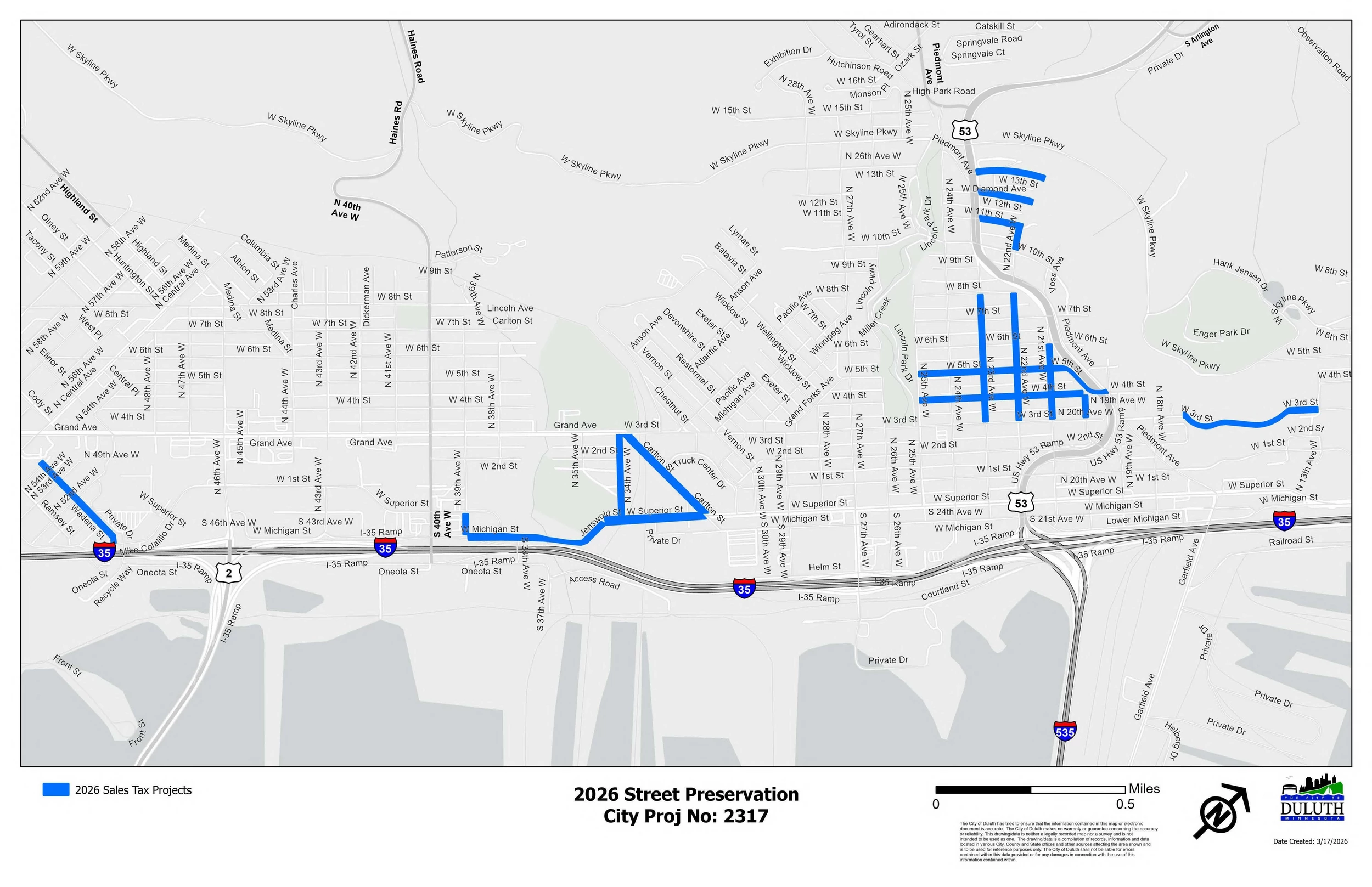
This is the busiest area for the City of Duluth's planned street projects, with several streets getting some kind of work done in 2026. In total, 4.26 miles of city streets will be surfaced in this area. The list of streets includes:
34th Avenue West: 0.23 miles from Grand Avenue to Superior Street
Carlton Street: 0.33 miles from West Superior Street to Grand Avenue
39th Avenue West: 0.07 miles from Michigan to Superior Street
West Superior Street: 0.29 miles from Carlton Street to Jenswold Street
Jenswold Street: 0.07 miles from West Superior Street to West Michigan Street
West Michigan Street: 0.32 miles from Jenswold Street to 39th Avenue West
21st Avenue West: 0.21 miles from 3rd to 6th Streets
West 4th Street: 0.45 miles from 20th Avenue West to 25th Avenue West
West 5th Street: 0.43 miles from the bridge over TH53 to 25th Avenue West
20th Avenue West: 0.07 miles from 3rd to 4th Streets
22nd Avenue West: 0.35 miles from 3rd to 8th Streets
23rd Avenue West: 0.14 miles from 3rd to 5th Streets
23rd Avenue West: 0.21 miles from 5th to 8th Streets
West 12th Street: 0.13 miles from TH53 to dead end east
West 11th Street: 0.11 miles from TH53 to 22nd Avenue West
22nd Avenue West: 0.07 miles from West 11th Street to West 10th Street

West 13th Street: 0.14 miles from TH53 to dead end east
West 3rd Street: 0.35 miles from 13th Avenue West to 17th Avenue West
Wadena Street: 0.29 miles from Mike Colalillo Drive to 54th Avenue West
Project Area 3: Gary-New Duluth, Duluth Heights, Kenwood, Chester Park (UMD)
This project area is more geographically spread out, including projects in three distinctly different areas of Duluth. This is the second-largest project area, with 4.18 miles of street work across 12 different roads bring worked on in this area. Here's how it breaks down:

Neighborhood Area 1: Gary-New Duluth:
Gary Street: 1.14 miles from Highway 23 to Becks Road
West Dickson Street: 0.51 miles from Highway 23 to the dead end to the west past 108th Avenue West
Hudson Boulevard: 0.18 miles from Commonwealth Avenue to Herman Avenue
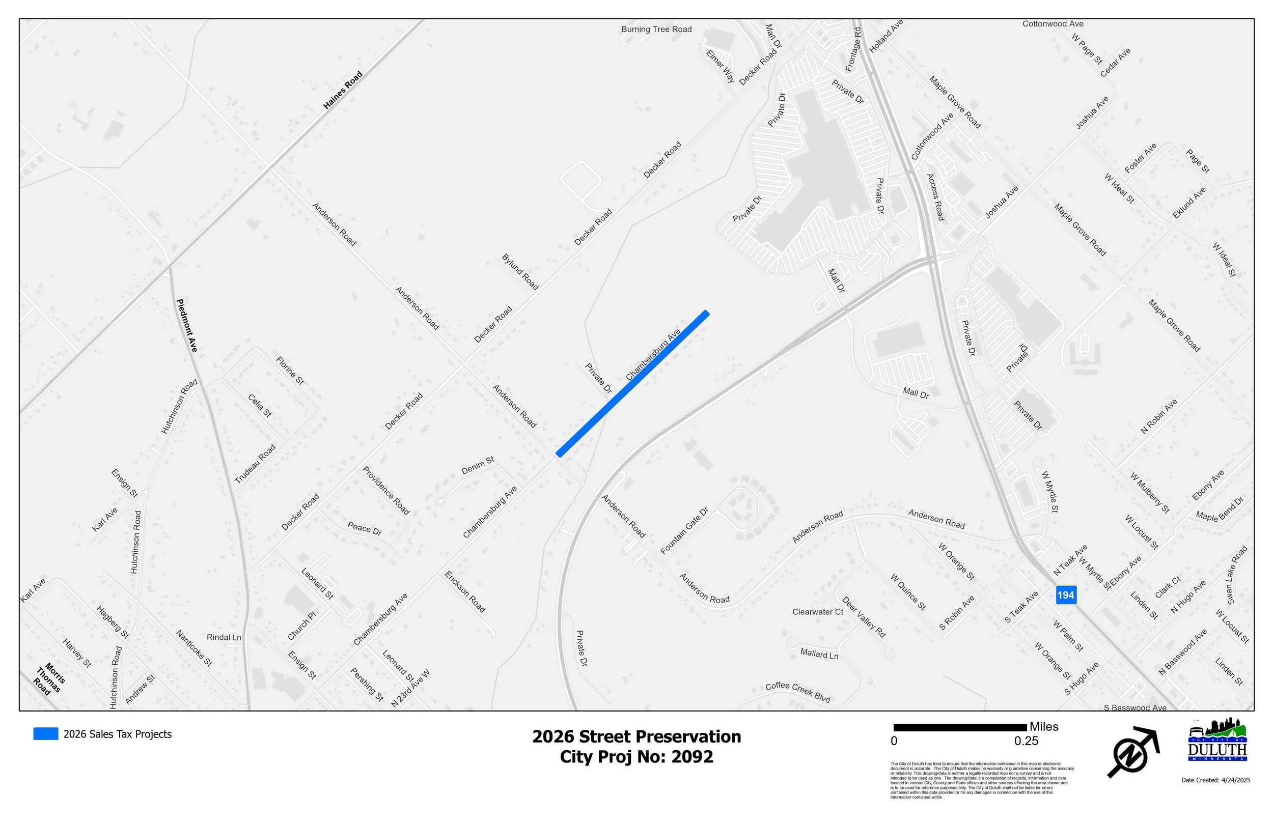
Neighborhood Area 2: Duluth Heights:
Chambersburg Avenue: 1.14 miles from Anderson Road to the dead end at the northern end of the road
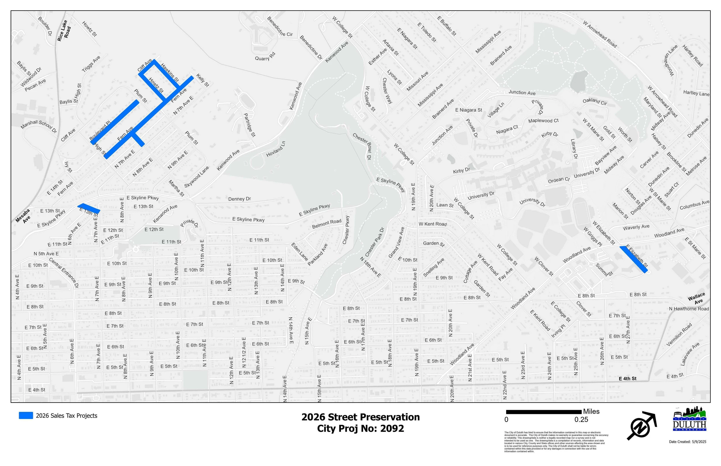
Neighborhood Area 3 Kenwood & Chester Park/UMD:
East 13th Street: 0.07 miles from 7th Avenue East to Skyline Parkway
Fern Avenue: 0.38 miles from High Street to Kelly Street
Martha Street: 0.06 miles from Fern Avenue to 7th Avenue East
Howtz Street: 0.13 miles from Fern Avenue to Cliff Avenue
Cliff Avenue: 0.06 miles from Howtz Street to Hawkins Street
Hawkins Street: 0.12 miles from Cliff Avenue to Fern Avenue
Boulevard Place: 0.22 miles from High Street to Plum Street
East Elizabeth Street: 0.17 miles from Woodland Avenue to the cul-de-sac
13 Places a Duluthian Would Be Ashamed to Admit They've Never Been
Gallery Credit: Nick Cooper - TSM Duluth
More From KOOL 101.7