‘Enhanced’ Risk Of Severe Storms For Twin Ports Tuesday
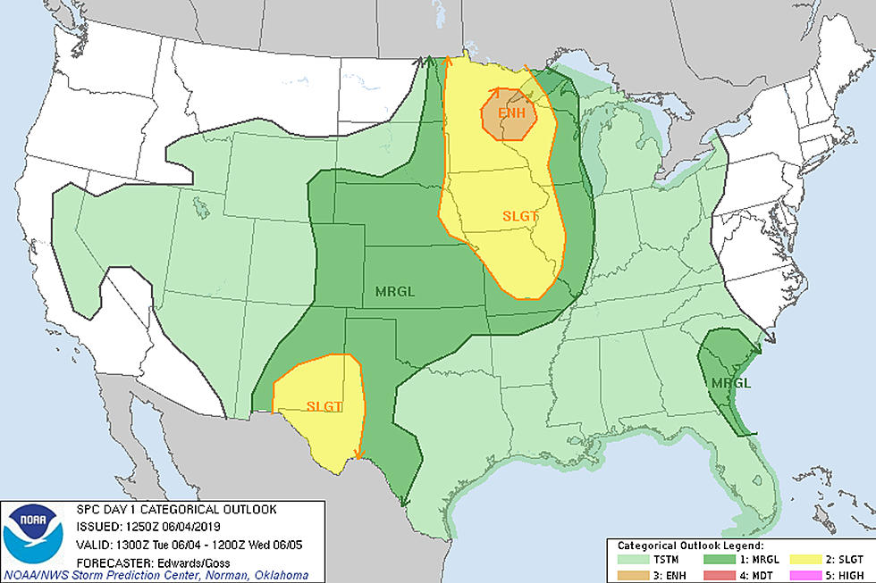
The first significant chance of severe weather for the season in the Twin Ports area appears to be on the way for Tuesday afternoon and evening. The National Weather Service Storm Prediction Center is pointing to an "enhanced" risk of severe thunderstorms around the head of Lake Superior and down toward the Twin Cities for today. This just so happens to be the bullseye of greatest likelihood of severe weather around the country today, but what does an "enhanced" risk mean?
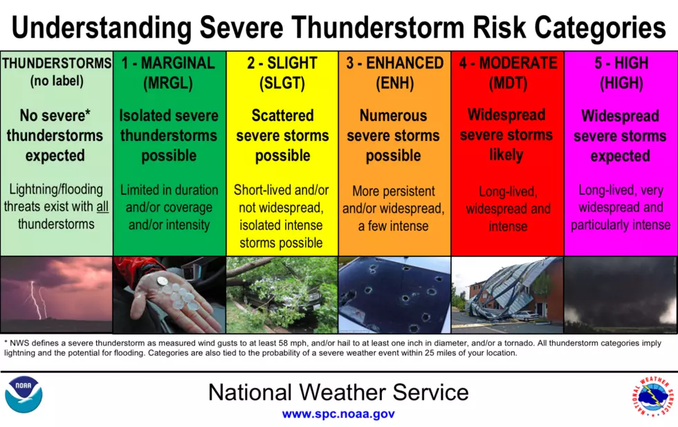
The Storm Prediction Center uses a total of 6 categories to define the threats of severe thunderstorms, with 5 of them associated with severe weather. The "enhanced" category that the Twin Ports falls under today is right in the middle of the severe categories, defined as "Numerous severe storms possible. More persistent and/or widespread, a few intense". You can see the full chart below.
This sets up a scenario where there is definitely a notable chance that strong to severe storms could impact much of the region, especially the portion noted in orange in the map above. Even storms that are not classified as severe can still be dangerous, with lightning being a key thing to be aware of. As always, in any instance of a thunderstorm approaching, it is best to take shelter in a sturdy building. You can see all of the National Weather Service's thunderstorm safety tips here.
As with any strong or severe storms, the potential of a tornado can't be completely ruled out, but it is not expected to be a primary threat. The greatest threats that could come from any severe weather that develops today here in the Northland would be in the form of damaging wind gusts and large hail.
Storm timing for the immediate Twin Ports area is currently predicted with storm chances starting between 3 and 5 pm, and the greatest chances between 6 and 11 pm. Models are pointing to storms developing and moving in a southeastern direction, which means areas Northwestern and North-Central Minnesota will be among the first places to see storm development today. Storms will continue to sweep southeast toward the Twin Ports and East Central Minnesota, expected to increase in intensity as they move through our area.
After our stormy afternoon and evening, the remainder of the week looks pretty pleasant, with generally summerlike temperatures and dry conditions into the weekend. expected.
More From KOOL 101.7