Duluth NWS Warning This Weekend’s Storms Could Be Especially Bad
If you follow the weather at all, you've probably heard that the atmosphere through the first half of the weekend is primed for some especially bad weather. Joe Moore, Warning Coordination Meteorologist with the Duluth office of the National Weather Service, is warning that storms in the forecast have the potential to be as bad as those that caused a widespread mess in 2016.
Moore tweeted Friday that it can be "challenging to communicate more significant severe storms when we've had so many days of 'garden variety' strong storms", but the storms expected Friday night into Saturday morning have the potential to be especially dangerous, leading Moore to call this weather event on the horizon to the public's attention.
Moore explained that the storms expected tonight have the potential to lead to a similar outcome to that of the squall line that blew through the Northland July 20-21 in 2016. The storm report from the National Weather Service for that 2016 storm details an overnight storm that brought wind speeds up to 75 mph in Ashland, nearly 50 mph in Duluth, and left people without power for days in some cases as crews cleared trees and repaired power lines from a massive blowdown of trees across the region. If you don't remember, that was the same storm that led to this damage at a Duluth gas station on Arrowhead Road.
Moore shared on Twitter earlier in the day on Friday a model run for tonight's storm that looks eerily similar to that of 2016, with massive storm putting the Twin Ports at the center of the bowed-out region of this storm system. With a line of severe storms of this nature, the bowed-out section is the area with the strongest chances of powerful straight-line winds that could cause damage like that seen in 2016.
There will also be a second round of severe weather expected Saturday night, giving the Northland two chances this weekend to see dangerous storms that could cause widespread damage.

When will the first round of storms arrive? The Twin Ports area can expect to see tonight's line of storms sweep through between 11 pm and 2 am, pushing off to the east through the early hours of Saturday morning.
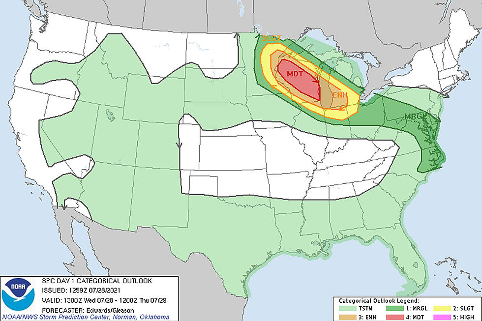
A rare "moderate" storm risk has been issued for the Twin Ports area, spanning westward to Brainerd, Grand Rapids, and Bemidji. As the graphic explains, winds in excess of 75 mph are possible, which could lead to power outages and downed trees. Isolated hail up to 1.5 inches and the slight possibility of a tornado are possibilities, but the main concern remains powerful winds for Friday night's storm.

After this round of storms moves through, Saturday will be hot and humid, fueling another round of storms Saturday afternoon and evening. The Duluth NWS office anticipates the timeframe for Saturday's storms in the late afternoon hours on Saturday for the Twin Ports area toward the Twin Cities, and areas like Hayward, Ashland, and Bayfield seeing those storms through the later evening hours.
Saturday's afternoon and evening storms could bring with them the normal severe storm threats that include dangerous lighting, hail, and wind, but the primary threat appears to be the possibility of flash flooding.

Due to the timing of these storms, weather officials are asking the public to consider having ways to be alerted to severe weather conditions through the weekend. While radio and TV stations broadcast EAS alerts with this type of information, you won't get these alerts if your radio/TV is off, or if you are watching streaming TV programming. Having a weather radio or an app on your phone that gives audio alerts for severe weather is a good idea. Many common weather apps offer this functionality, so if you have one on your phone, be sure the option is turned on to ensure you get alerts for severe conditions.
More From KOOL 101.7