What Is Really Considered ‘Northern Minnesota’?
I have called Minnesota home my entire life. By many definitions, I've actually called "Northern Minnesota" home for almost my entire life. Aside from the first couple years of my life, I grew up in the Brainerd Lakes area, I attended college in Bemidji, and I've called Duluth home ever since.
Even though looking at a map, some of these places are more "Central Minnesota" than truly "Up North", the influx of visitors from places like the Twin Cities calling these vacation hotspots "Northern Minnesota" and "Up North" have always been a part of my lexicon and moreover just a fiber of my being. I've occasionally had one of those pointless debates with friends of whether or not we really live in "Northern Minnesota", but I haven't really given it deep thought in quite awhile. That is, until a Facebook post I recently saw got me thinking about the subject again.
The post, seen in an area Facebook group, included a map of Minnesota with two lines, dividing the state into "Northern Minnesota", "Central Minnesota", and "Southern Minnesota". The lines, arbitrarily drawn, portray the border for "Northern Minnesota" running along a line roughly through towns like Mahnomen, Grand Rapids, and Sliver Bay, while "Southern Minnesota" is a line that approximately extends through from Benson to Monticello and Forest Lake.
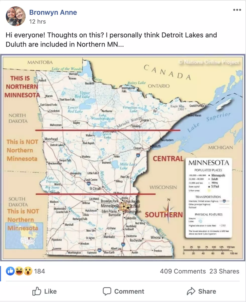
While the lines look skewed north, I did check them and they do run almost exactly 1/3 and 2/3 from the Iowa border, respectively (ignoring the Northwest Angle).
A number of people in the comments point out that it is all relative. With such a sizable amount of the state's population calling the Twin Cities area home, those of us in "vacation country" have just adopted "Northern Minnesota" as the label of where we live, even if it really is smack in the center of the state in some cases (depending on what town you're talking about).

So, what is the colloquial borderline for what is considered "Northern Minnesota"? Even though the map shows the technical line, what is the acceptable standard? I've heard people suggest Highway 2, which isn't too far off from the line on the map. One person in the Facebook post's comments suggested Minnesota Highway 210 as the borderline for the northern part of the state. The person didn't offer much of an explanation, but it kind of makes sense.
Sure, 210 isn't a straight line. It heads south and west from Duluth, through Brainerd, then to Breckenridge, on the Minnesota side of the border, across from Wahpeton, North Dakota. The thing about that ending point for the road is that it is almost exactly in the north-south center of the state's western border. It also doesn't have any of the characteristics of what people think of when they think "Northern Minnesota". It is very much farm country.
Because of that, I want to offer a modification. You could make the argument that "Northern Minnesota" is more defined by the characteristics of thick forests, lakes, and rugged terrain, and less by a geographic line. If you subscribe to that logic, Highway 210 would conveniently be a good borderline, at least through the Brainerd area. If you want to follow the lakes and trees, probably consider US Highway 10 west of Brainerd, which heads northwest to Moorhead. That part of the state still gets flat and generally treeless, but less so than Breckenridge. Also, Detroit Lakes is another "lakes area" that gets a lot of tourism, which happens to be on Highway 10.
So, do you agree with my "Northern Minnesota" border combo platter of Highway 10 west of Brainerd and Highway 210 east of Brainerd? Do you subscribe to the arbitrary line on the map? Something else? Let us know!
14 Of The Most Minnesota MNDOT Messages
More From KOOL 101.7